The Indus is the longest river system that reaches into India, although most of its length passes through Pakistan. The Godavari is the longest river entirely in India.
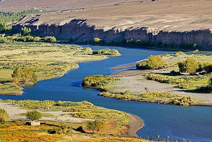
 The Indus River in India's Ladakh Region.
The very term India is an adaptation of the word Indus. That word itself was an indirect derivation from the Sanskrit word Sindh, which the localities used to address the Indus River. With religious, economic, cultural, and social importance, the river Ganga is undoubtedly the soul of the country. Meanwhile, the Brahmaputra River is a major support pillar of this nation. The importance of these three major rivers of India lies beyond what words can describe.
The Indus is the longest river system that reaches into India, although most of its length passes through Pakistan. The Godavari is the longest river entirely in India.

The Indus River in India's Ladakh Region.
The very term India is an adaptation of the word Indus. That word itself was an indirect derivation from the Sanskrit word Sindh, which the localities used to address the Indus River. With religious, economic, cultural, and social importance, the river Ganga is undoubtedly the soul of the country. Meanwhile, the Brahmaputra River is a major support pillar of this nation. The importance of these three major rivers of India lies beyond what words can describe.
Major Rivers are the Backbone of the Indian Nation
The economic, ecological, cultural, and religious aspects of the three eminent rivers, the Indus, Ganga, and Brahmaputra, are what make them the very backbone and pride of India.
1,976 miles long, the river Indus, originating in the locale of Lake Mansarovar in Tibet before it enters India, flows through Ladakh up to Punjab, and unites with the Arabian Sea at the port of Karachi. The Indus is the longest river of India. Punjab being the dynamic agricultural production center of India, it’s imperative supplier of water is Indus River.
The Brahmaputra, the second longest river (1,832 miles) to pass into India runs through three other countries. It initiates from the Angsi Glacier in the Himalayas, through Tibet into Arunachal Pradesh, India and, continuing its journey to the southwest, into Assam and southward through Bangladesh. There it empties into the Bay of Bengal after adapting different names all throughout its journey.
The river Ganga, arising in the western Himalayas of India, travels to the Bay of Bengal through Bangladesh. It serves as an economic and spiritual need of the civilians.
The Freshwater and Pride of India Threatened
The declaration of the dolphin as India’s national aquatic animal has highlighted the threatened existence of these marine mammals in both the Ganga and the Brahmaputra. Nearly extinct, only 3,000 dolphins are left, a quarter of what earlier existed. Threat to the national aquatic species is a threat to India’s pride altogether. The major reason behind this degradation is the contamination of both Ganga and Brahmaputra. Indus River is a habitat to nearly 150 species, few of which exist solely in this belt. It includes blind Indus River Dolphins subspecies of dolphin, endangered due to rising pollution on this stretch. In 2007, Ganga was categorized as the fifth most polluted river in the world, which is another disgrace to the country.
Believed to be the lifeline of thousands of citizens and the home of an extensive number of animals, these three major rivers of India are changing their courses and affecting the lives of those who depend on them. All this is negatively affecting the biodiversity, causing soil erosion, infertility of lands, flooding of riverbanks thereby destroying hundreds of houses and farms.
India's Mighty Rivers in Need of Immediate Conservation Interventions
Over the years, a great deal of research and action has taken place to alter these negative scenarios, nearly all meeting failure. The Ganga Action Plan from 1985 to 2000 was a major failure, even after the investment of 10 billion Indian Rupees. Revolutionary support of the local inhabitants and of overall country can bring a significant and positive change to this shameful and wretched scenario. Willing participation of every citizen is necessary to save the flora and fauna, the endangered species by rejection to pollution and deforestation.
Over the years, a great deal of research and action has taken place to alter these negative scenarios, nearly all meeting failure. The Ganga Action Plan from 1985 to 2000 was a major failure, even after the investment of 10 billion Indian Rupees. Revolutionary support of the local inhabitants and of overall country can bring a significant and positive change to this shameful and wretched scenario. Willing participation of every citizen is necessary to save the flora and fauna, the endangered species by rejection to pollution and deforestation.
The Longest Rivers In India
Rank Major River Systems Wholly or Partially in India Length 1 Indus 1,976 miles (shared with Pakistan and China) 2 Brahmaputra–Tsangpo 1,832 miles (shared with China, Nepal, Bangladesh, and Bhutan) 3 Ganges–Hooghly–Padma 1,628 miles (shared with Bangladesh, Nepal, and China) 4 Godavari 910 miles 5 Sutlej 852 miles (shared with Pakistan and China) 6 Yamuna 851 miles 7 Krishna 808 miles 8 Narmada 801 miles 9 Chenab 675 miles (shared with Pakistan) 10 Ghaghara 671 miles (shared with Nepal and China)
| Rank | Major River Systems Wholly or Partially in India | Length |
|---|---|---|
| 1 | Indus | 1,976 miles (shared with Pakistan and China) |
| 2 | Brahmaputra–Tsangpo | 1,832 miles (shared with China, Nepal, Bangladesh, and Bhutan) |
| 3 | Ganges–Hooghly–Padma | 1,628 miles (shared with Bangladesh, Nepal, and China) |
| 4 | Godavari | 910 miles |
| 5 | Sutlej | 852 miles (shared with Pakistan and China) |
| 6 | Yamuna | 851 miles |
| 7 | Krishna | 808 miles |
| 8 | Narmada | 801 miles |
| 9 | Chenab | 675 miles (shared with Pakistan) |
| 10 | Ghaghara | 671 miles (shared with Nepal and China) |

